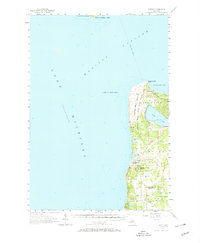
1957 Map of Empire
USGS Topo · Published 1969About this map
Sleeping Bear Dunes State Park and D H Day State Park anchor this coastal landscape along the shores of Lake Michigan in the mid-1950s. The map illustrates a region defined by dramatic glacial features like Sleeping Bear Point, Devils Hole, and the Empire Bluffs. Inland from the massive dunes, the hydrology is shaped by Glen Lake and smaller basins such as North Bar Lake and South Bar Lake.
Find a feature on this map
31 named features on this map. Tap any name to fly to it.
Don’t see what you’re looking for? This feature index may not catch every label — zoom into the map to look around manually.
Map Details
Editions of this 1957 Empire Map
2 editions found
Other maps of this area

1954 · Traverse City
USGS Topo · 1:250,000

1954 · Escanaba
USGS Topo · 1:250,000

1954 · Manitowoc
USGS Topo · 1:250,000

1955 · Cheboygan
USGS Topo · 1:250,000

1956 · North Manitou
USGS Topo · 1:62,500

1956 · Thompsonville
USGS Topo · 1:62,500

1956 · Frankfort
USGS Topo · 1:62,500

1957 · Escanaba
USGS Topo · 1:250,000

1957 · Empire
USGS Topo · 1:62,500

1957 · Maple City
USGS Topo · 1:62,500