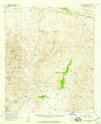
1958 Map of Empire Mountains
USGS Topo · Published 1959About this map
Empire Mountains and the northern slopes of the Santa Rita Mountains dominate this 1958 landscape, a territory defined by high-desert ranching and a legacy of hard-rock mining. The iconic Empire Ranch serves as a central hub, surrounded by smaller holdings like Andrada Ranch and High Haven Ranch, illustrating the sparse but organized settlement patterns of Pima County. Notable for its concentration of mineral prospects, the map labels several operations including the Total Wreck Mine, California Mine, and Helena Mine tucked into the canyons. In the southern reaches, the mining camp of Greaterville appears near Empire Sch, marking the transition into the Coronado National Forest. In the north, the Southern Pacific railroad cuts through the terrain near Mescal, passing over the Amole Overpass and beneath the Pantano Underpass near the waters of Cienega Creek.
Find a feature on this map
84 named features on this map. Tap any name to fly to it.
Don’t see what you’re looking for? This feature index may not catch every label — zoom into the map to look around manually.
Map Details
Editions of this 1958 Empire Mountains Map
3 editions found
Other maps of this area

1904 · Patagonia
USGS Topo · 1:125,000

1904 · Tucson
USGS Topo · 1:125,000

1905 · Patagonia
USGS Topo · 1:125,000

1905 · Tucson
USGS Topo · 1:125,000

1915 · Benson
USGS Topo · 1:125,000

1922 · Agus Caliente
USGS Topo · 1:62,500

1926 · Whetstone
USGS Topo · 1:62,500

1926 · Helvetia
USGS Topo · 1:62,500

1932 · Elgin
USGS Topo · 1:62,500

1938 · Huachuca
USGS Topo · 1:62,500