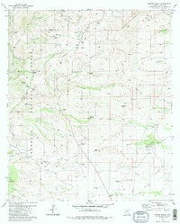
1981 Map of Empire Ranch
USGS Topo · Published 1986About this map
Empire Ranch serves as the focal point for this area of Pima County, situated at the eastern edge of the Coronado National Forest. This landscape is defined by its ranching heritage and early mining activity, with settlements like Greaterville and Rosemont Camp appearing alongside legacy sites such as the Helena Mine. The terrain is deeply incised by drainage networks including Davidson Canyon and Empire Gulch, where water sources like Rosemont Springs and Oak Tree Windmill were essential for sustaining cattle and homesteads.
Find a feature on this map
57 named features on this map. Tap any name to fly to it.
Don’t see what you’re looking for? This feature index may not catch every label — zoom into the map to look around manually.
Map Details
Editions of this 1981 Empire Ranch Map
3 editions found
Other maps of this area

1904 · Patagonia
USGS Topo · 1:125,000

1905 · Patagonia
USGS Topo · 1:125,000

1922 · Agus Caliente
USGS Topo · 1:62,500

1926 · Helvetia
USGS Topo · 1:62,500

1932 · Elgin
USGS Topo · 1:62,500

1940 · Elgin
USGS Topo · 1:62,500

1947 · Elgin
USGS Topo · 1:62,500

1948 · Elgin
USGS Topo · 1:24,000

1948 · Sonoita
USGS Topo · 1:24,000

1956 · Nogales
USGS Topo · 1:250,000