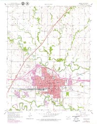
1957 Map of Emporia
USGS Topo · Published 1979About this map
Emporia serves as the focal point of this Lyons County survey, situated at the confluence of the Neosho River and the Cottonwood River. The map captures a transitional period for the city, showing the expansion of the urban area toward the Kansas Turnpike and the Emporia Interchange. Educational institutions are prominent features, including the Kansas State Teachers College and the College of Emporia, alongside numerous neighborhood schools like Walnut Sch and Whittier Sch.
Find a feature on this map
56 named features on this map. Tap any name to fly to it.
Don’t see what you’re looking for? This feature index may not catch every label — zoom into the map to look around manually.
Map Details
Editions of this 1957 Emporia Map
3 editions found
Other maps of this area

1885 · Eskridge
USGS Topo · 1:125,000

1888 · Emporia
USGS Topo · 1:125,000

1889 · Eskridge
USGS Topo · 1:125,000

1894 · Emporia
USGS Topo · 1:125,000

1894 · Eskridge
USGS Topo · 1:125,000

1955 · Hutchinson
USGS Topo · 1:250,000

1957 · Lang
USGS Topo · 1:24,000

1957 · Emporia
USGS Topo · 1:24,000

1957 · Plymouth
USGS Topo · 1:24,000

1959 · Hutchinson
USGS Topo · 1:250,000