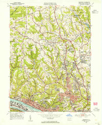
1953 Map of Emsworth
USGS Topo · Published 1955About this map
The Ohio River flows through the southern edge of this map, anchored by the Emsworth Dam and the industrialized western tip of Neville Island. In the early 1950s, this portion of Allegheny County shows a landscape transitioning from the wooded hills of Sewickley Heights to the denser suburban corridors of West View and Bellevue. Notable institutional landmarks define the social geography, including the expansive Dixmont State Hospital overlooking the river and numerous religious academies such as Mt Nazareth Academy and St Benedicts Academy. Northward, the map details the recreation and infrastructure that served the growing population, from the North Park Lake area and the Filtration Plant to the Auto Racetrack near Bear Run. This era also reveals a high concentration of memorial sites, including the Tree of Life Memorial Park Cemetery and Allegheny County Memorial Park (Cemetery).
Find a feature on this map
99 named features on this map. Tap any name to fly to it.
Don’t see what you’re looking for? This feature index may not catch every label — zoom into the map to look around manually.
Map Details
Editions of this 1953 Emsworth Map
This is the sole edition of this map. No revisions or reprints were ever made.
Other maps of this area

1904 · Mc Keesport
USGS Topo · 1:62,500

1904 · Carnegie
USGS Topo · 1:62,500

1906 · Carnegie
USGS Topo · 1:62,500

1906 · Sewickley
USGS Topo · 1:62,500

1907 · Pittsburg
USGS Topo · 1:62,500

1908 · Sewickley
USGS Topo · 1:62,500

1908 · Carnegie
USGS Topo · 1:62,500

1908 · New Kensington
USGS Topo · 1:62,500

1910 · New Kensington
USGS Topo · 1:62,500

1948 · Pittsburgh West
USGS Topo · 1:24,000