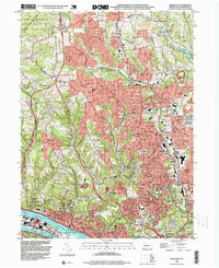
1993 Map of Emsworth
USGS Topo · Published 1999About this map
Dixmont State Hospital anchors the southwestern riverside in this late-twentieth-century study of the northern Pittsburgh suburbs. The landscape shows a period of significant suburban infill and institutional growth, with large facilities like the Vincentian High School and North Allegheny High School serving expanding residential communities such as Ingomar and Franklin Park. The rugged topography of the North Hills is reflected in the winding paths of Lowries Run and Pine Creek, while the southern border is defined by the industrial and transport corridor of the Ohio River and the Penn Central railroad.
Find a feature on this map
64 named features on this map. Tap any name to fly to it.
Don’t see what you’re looking for? This feature index may not catch every label — zoom into the map to look around manually.
Map Details
Editions of this 1993 Emsworth Map
This is the sole edition of this map. No revisions or reprints were ever made.
Other maps of this area

1904 · Mc Keesport
USGS Topo · 1:62,500

1904 · Carnegie
USGS Topo · 1:62,500

1906 · Carnegie
USGS Topo · 1:62,500

1906 · Sewickley
USGS Topo · 1:62,500

1907 · Pittsburg
USGS Topo · 1:62,500

1908 · Sewickley
USGS Topo · 1:62,500

1908 · Carnegie
USGS Topo · 1:62,500

1908 · New Kensington
USGS Topo · 1:62,500

1910 · New Kensington
USGS Topo · 1:62,500

1948 · Pittsburgh West
USGS Topo · 1:24,000