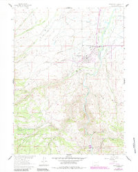
1961 Map of Encampment
USGS Topo · Published 1984About this map
The riverfront settlements of Encampment and Riverside serve as the primary hubs of this landscape, situated where the high plains meet the timbered slopes of the Medicine Bow National Forest. The map captures a detailed snapshot of the region's agricultural and industrial infrastructure, featuring the Union Pacific rail line and an extensive network of irrigation canals like the Wagoner Enlarged Ditch and Pacific Ditch that draw from the Encampment River. Local family history is well-represented through numerous named homesteads and outposts, including the Oldman Ranch, Finch Ranch, and the remote Finch Cow Camp. To the west, the terrain rises sharply into the mountains, where several prospects and the Tram suggest a history of mineral exploration and transport. The Encampment Cem and Cruse Landing Strip further document the development of these Carbon County communities during the mid-twentieth century.
Find a feature on this map
47 named features on this map. Tap any name to fly to it.
Don’t see what you’re looking for? This feature index may not catch every label — zoom into the map to look around manually.
Map Details
Editions of this 1961 Encampment Map
5 editions found
Other maps of this area

1939 · Saratoga
USGS Topo · 1:125,000

1954 · Rawlins
USGS Topo · 1:250,000

1958 · Rawlins
USGS Topo · 1:250,000

1961 · Red Mountain
USGS Topo · 1:24,000

1961 · Gunst Reservoir
USGS Topo · 1:24,000

1961 · Encampment
USGS Topo · 1:24,000
1961 · Blackhall Mountain
USGS Topo · 1:24,000
1961 · Dudley Creek
USGS Topo · 1:24,000
1961 · Cow Creek Ranch
USGS Topo · 1:24,000
1961 · Cow Creek
USGS Topo · 1:24,000