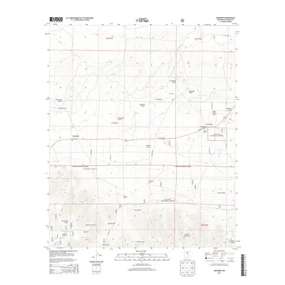
2013 Map of Encinoso
USGS Topo · Published 2013About this map
Encinoso stands at a transition between the high peaks of the Capitan Mountains and the arid ranchlands of Lincoln County. The landscape is defined by its canyon systems, including Cottonwood Canyon, Merchant Canyon, and Richardson Canyon, which channel seasonal water from the heights toward the plains. Significant landholdings like the Block Ranch, Edgar Ranch, and Koprian Ranch reflect the area's deep-rooted ranching tradition, where water sources such as Macho Spring and Gum Spring are vital. The presence of the Block Ranch Airport suggests the vastness of these properties and the importance of air travel for remote rural connectivity. Southward, the terrain climbs steeply into the Lincoln National Forest, reaching Minckey Ridge and West Mtn, where resource management is evident at Sawmill Tank. This 2013 survey illustrates how modern infrastructure, such as NM-246, navigates a topography that still dictates the placement of settlements and seasonal lodges like Sportsmans Lodge.
Find a feature on this map
80 named features on this map. Tap any name to fly to it.
Don’t see what you’re looking for? This feature index may not catch every label — zoom into the map to look around manually.
Map Details
Editions of this 2013 Encinoso Map
This is the sole edition of this map. No revisions or reprints were ever made.
Other maps of this area

1934 · Capitan
USGS Topo · 1:48,000

1935 · Capitan Mountains
USGS Topo · 1:48,000

1937 · Capitan
USGS Topo · 1:62,500

1940 · Capitan Mountains
USGS Topo · 1:62,500

1955 · Roswell
USGS Topo · 1:250,000

1958 · Roswell
USGS Topo · 1:250,000

1962 · Roswell
USGS Topo · 1:250,000

1973 · Jacob Spring
USGS Topo · 1:24,000

1973 · Jicarilla Peak
USGS Topo · 1:24,000
1973 · Capitan
USGS Topo · 1:24,000