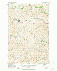
1950 Map of Endicott
USGS Topo · Published 1963About this map
Endicott serves as the primary hub of this Whitman County landscape, situated along the Union Pacific railroad line within the distinctive terrain of Rebel Flat. The map reveals a highly structured agricultural and water network in the middle of the century, where drainage systems like Union Flat Creek and Alkali Creek carve through the plateau toward the Palouse River in the north and Penawawa Creek in the south.
Find a feature on this map
20 named features on this map. Tap any name to fly to it.
Don’t see what you’re looking for? This feature index may not catch every label — zoom into the map to look around manually.
Map Details
Editions of this 1950 Endicott Map
Other maps of this area

1903 · Oakesdale
USGS Topo · 1:125,000

1905 · Oakesdale
USGS Topo · 1:125,000

1910 · Pullman
USGS Topo · 1:125,000

1950 · La Crosse
USGS Topo · 1:62,500

1950 · Penawawa
USGS Topo · 1:62,500

1950 · Endicott
USGS Topo · 1:62,500

1950 · Hay
USGS Topo · 1:62,500

1952 · Hay
USGS Topo · 1:62,500

1952 · La Crosse
USGS Topo · 1:62,500

1955 · Pullman
USGS Topo · 1:250,000