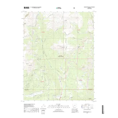
2019 Map of Engineer Mountain
USGS Topo · Published 2019About this map
Engineer Mountain and the high-altitude terrain of the San Juan National Forest define this landscape along the border of San Juan and La Plata counties. The 2019 survey documents a complex network of forest roads and trails, including the historic Rico-Silverton-Co-Trail and the Grayrock Spur, which navigate the steep elevations between Sliderock Ridge and the West Needle Mountains. This area serves as a critical drainage basin for numerous alpine waterways, with Cascade Creek and Lime Creek cutting through the topography. In the southern portion of the map, Purgatory Flat provides a rare level landing amidst peaks like Grayrock Peak and Potato Hill. The map also captures significant transportation crossings such as Coal Bank Pass, providing a contemporary view of this transition point between the northern and southern San Juan ranges.
Find a feature on this map
72 named features on this map. Tap any name to fly to it.
Don’t see what you’re looking for? This feature index may not catch every label — zoom into the map to look around manually.
Map Details
Editions of this 2019 Engineer Mountain Map
This is the sole edition of this map. No revisions or reprints were ever made.
Other maps of this area
1897 · Telluride
USGS Topo · 1:62,500
1897 · Silverton
USGS Topo · 1:62,500
1898 · Engineer Mountain
USGS Topo · 1:62,500
1900 · Engineer Mountain
USGS Topo · 1:62,500
1900 · Needle Mountains
USGS Topo · 1:62,500
1901 · Silverton
USGS Topo · 1:62,500
1902 · Needle Mountains
USGS Topo · 1:62,500
1902 · Silverton
USGS Topo · 1:62,500
1904 · Telluride
USGS Topo · 1:62,500
1908 · Engineer Mountain
USGS Topo · 1:62,500