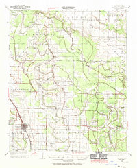
1937 Map of England
USGS Topo · Published 1970About this map
Bakers Bayou and Crooked Creek wind through a landscape defined by an extensive drainage network in this Depression-era survey of Lonoke County. The settlement of England serves as a primary hub, connected to outlying communities like Coy, Ryan, and Humnoke via the St Louis Southwestern Railroad. This 1937 field survey, sponsored by the Arkansas Geological Survey and supported by the Works Progress Administration, reveals a densely settled rural society. Numerous country schools and churches—such as Eagle Sch, St James Ch, and Zion Chapel—dot the township lines, marking the social centers of the Richwoods and Lafayette districts. The transition from natural wetlands like McGregor Brake to an engineered agricultural landscape is evident through labels such as the Caney Ditch and various unnamed drainage canals, illustrating the massive effort to manage the alluvial plains for farming.
Find a feature on this map
63 named features on this map. Tap any name to fly to it.
Don’t see what you’re looking for? This feature index may not catch every label — zoom into the map to look around manually.
Map Details
Editions of this 1937 England Map
3 editions found
Other maps of this area

1891 · Little Rock
USGS Topo · 1:125,000

1893 · Little Rock
USGS Topo · 1:125,000

1932 · Pastoria
USGS Topo · 1:62,500

1935 · Altheimer
USGS Topo · 1:62,500

1935 · Hazen
USGS Topo · 1:62,500

1935 · Pastoria
USGS Topo · 1:62,500

1937 · Stuttgart
USGS Topo · 1:62,500

1937 · England
USGS Topo · 1:48,000

1939 · Keo
USGS Topo · 1:31,680

1939 · Stuttgart
USGS Topo · 1:62,500