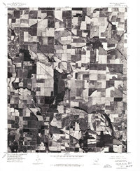
1975 Map of England NE
USGS Topo · Published 1977About this map
Bayou Meto meanders through the agricultural heart of the Grand Prairie region in this orthophotoquad, which utilizes rectified aerial imagery to provide a detailed view of the landscape as it appeared in the mid-1970s. The terrain is defined by a dense grid of geometric farm plots and irrigation patterns, reflecting the area's intensive cultivation. The small settlement of Culler sits amidst this productive landscape, serving as a focal point for the surrounding rural community. The winding path of Crooked Creek provides a natural contrast to the straight-line boundaries of the rice and soybean fields that dominate Lonoke County. This specialized map format allows for the precise study of land use and drainage patterns, documenting the intersection of natural waterways and modern agricultural engineering.
Find a feature on this map
3 named features on this map. Tap any name to fly to it.
Don’t see what you’re looking for? This feature index may not catch every label — zoom into the map to look around manually.
Map Details
Editions of this 1975 England NE Map
This is the sole edition of this map. No revisions or reprints were ever made.
Other maps of this area

1935 · Hazen
USGS Topo · 1:62,500

1937 · Stuttgart
USGS Topo · 1:62,500

1937 · England
USGS Topo · 1:48,000

1939 · Stuttgart
USGS Topo · 1:62,500

1940 · Lonoke
USGS Topo · 1:62,500

1941 · Hazen
USGS Topo · 1:62,500

1943 · England
USGS Topo · 1:62,500

1948 · Helena
USGS Topo · 1:250,000

1949 · Lonoke
USGS Topo · 1:62,500

1950 · Helena
USGS Topo · 1:250,000