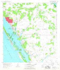
1956 Map of Englewood
USGS Topo · Published 1968About this map
Englewood and Grove City anchor this mid-century survey of the Gulf Coast, where the boundary between Sarasota and Charlotte Counties cuts across a landscape of emerging waterfront neighborhoods and tidal wetlands. The era's focus on coastal development is evident in the layout of Manasota Key and the residential clusters at Point of Pines and New Point Comfort. Interior areas remain largely undeveloped, characterized by cattle operations like the Flying A Ranch and Two V Ranch, alongside numerous drainage systems including Oyster Creek, Ainger Creek, and Godfrey Creek. Local life centers on landmarks such as the Englewood Sch and the Placida Ch, while the shoreline features established coastal access at Punta Gorda Beach and the natural break at Stump Pass. The map provides a detailed view of the Lemon Bay waterscape before the heavy canalization and large-scale dredging of later decades.
Find a feature on this map
26 named features on this map. Tap any name to fly to it.
Don’t see what you’re looking for? This feature index may not catch every label — zoom into the map to look around manually.
Map Details
Editions of this 1956 Englewood Map
4 editions found
Other maps of this area

1944 · Myakka River
USGS Topo · 1:31,680

1944 · Venice
USGS Topo · 1:31,680

1956 · Murdock
USGS Topo · 1:24,000

1956 · Englewood
USGS Topo · 1:24,000

1956 · Tampa
USGS Topo · 1:250,000

1956 · Charlotte Harbor
USGS Topo · 1:250,000

1957 · Englewood NW
USGS Topo · 1:24,000

1957 · El Jobean
USGS Topo · 1:24,000

1957 · Punta Gorda SW
USGS Topo · 1:24,000

1957 · Placida
USGS Topo · 1:24,000