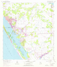
1956 Map of Englewood
USGS Topo · Published 1973About this map
Lemon Bay separates the mainland settlements from the coastal stretch of Manasota Key in this detailed 1950s record, which was updated with 1970s photodata to capture a period of rapid development. The early coastal community centers on Englewood and its namesake Englewood Sch, while further south, the grids of Grove City and the circular layout of Rotunda begin to take shape. These planned residential patterns contrast with the traditional agricultural footprints of the Flying A Ranch and Two V Ranch to the east. Several creeks, including Godfrey Creek and Oyster Creek, drain into the bay, which is punctuated by landmarks such as New Point Comfort and the Placida Ch. The map also documents aviation history through the Buchan Landing Field and nautical features like Stump Pass, reflecting an era of transition from cattle ranching to a modern waterfront economy.
Find a feature on this map
29 named features on this map. Tap any name to fly to it.
Don’t see what you’re looking for? This feature index may not catch every label — zoom into the map to look around manually.
Map Details
Editions of this 1956 Englewood Map
4 editions found
Other maps of this area

1944 · Myakka River
USGS Topo · 1:31,680

1944 · Venice
USGS Topo · 1:31,680

1956 · Murdock
USGS Topo · 1:24,000

1956 · Englewood
USGS Topo · 1:24,000

1956 · Tampa
USGS Topo · 1:250,000

1956 · Charlotte Harbor
USGS Topo · 1:250,000

1957 · Englewood NW
USGS Topo · 1:24,000

1957 · El Jobean
USGS Topo · 1:24,000

1957 · Punta Gorda SW
USGS Topo · 1:24,000

1957 · Placida
USGS Topo · 1:24,000