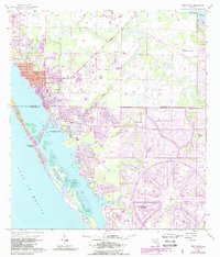
1956 Map of Englewood
USGS Topo · Published 1988About this map
Lemon Bay separates the coastal communities from the Gulf of Mexico in this mid-century topographic record, revised in the late 1980s to show the radial expansion of Rotonda. The map captures the distinct character of the Florida Gulf Coast, where inland waters like Gottfried Creek, Rock Creek, and Oyster Creek drain into the sound. Notable landmarks include the Englewood Sch, the Buchan Landing Field at the northern edge, and the Placida Ch located near Buck Creek. Significant residential growth is evident through the purple-tinted urban extensions, yet the map preserves earlier features such as the Flying A Ranch and the Two V Ranch in the eastern wetlands. The barrier islands are anchored by Englewood Beach and the Port Charlotte Beach State Forest, providing a detailed look at the coastline before more recent decades of intensive development.
Find a feature on this map
29 named features on this map. Tap any name to fly to it.
Don’t see what you’re looking for? This feature index may not catch every label — zoom into the map to look around manually.
Map Details
Editions of this 1956 Englewood Map
4 editions found
Other maps of this area

1944 · Myakka River
USGS Topo · 1:31,680

1944 · Venice
USGS Topo · 1:31,680

1956 · Murdock
USGS Topo · 1:24,000

1956 · Englewood
USGS Topo · 1:24,000

1956 · Tampa
USGS Topo · 1:250,000

1956 · Charlotte Harbor
USGS Topo · 1:250,000

1957 · Englewood NW
USGS Topo · 1:24,000

1957 · El Jobean
USGS Topo · 1:24,000

1957 · Punta Gorda SW
USGS Topo · 1:24,000

1957 · Placida
USGS Topo · 1:24,000