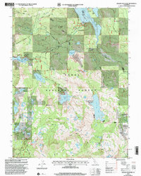
2000 Map of English Mountain
USGS Topo · Published 2003About this map
Tahoe National Forest encompasses this high-altitude landscape along the border of Nevada and Sierra counties. The terrain is defined by a dense concentration of alpine water bodies, including the expansive Jackson Meadows Reservoir and French Lake. Historical human activity is centered around the settlement of Summit City and the Baltimore Town Site, appearing here as markers of early Sierra Nevada industry and habitation near Meadow Lake. Resource extraction is evidenced by the Excelsior Mine and various prospects scattered across the ridges. A network of trails, most notably the Pacific Crest National Scenic Trail, navigates the complex topography between peaks like English Mountain and Haystack Mountain. The presence of a secluded Cemetery near the town sites and the Bent Monument further east provide specific points of interest for genealogists and local historians tracing the movement of people through these mountains.
Find a feature on this map
79 named features on this map. Tap any name to fly to it.
Don’t see what you’re looking for? This feature index may not catch every label — zoom into the map to look around manually.
Map Details
Editions of this 2000 English Mountain Map
This is the sole edition of this map. No revisions or reprints were ever made.
Other maps of this area

1890 · Sierraville
USGS Topo · 1:125,000

1891 · Downieville
USGS Topo · 1:125,000

1891 · Colfax
USGS Topo · 1:125,000

1891 · Truckee
USGS Topo · 1:125,000

1892 · Sierraville
USGS Topo · 1:125,000

1892 · Colfax
USGS Topo · 1:125,000

1893 · Truckee
USGS Topo · 1:125,000

1893 · Downieville
USGS Topo · 1:125,000

1894 · Colfax
USGS Topo · 1:125,000

1894 · Sierraville
USGS Topo · 1:125,000