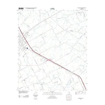
2012 Map of Ennis East
USGS Topo · Published 2012About this map
Telico and Creechville anchor the northeastern landscape of this Ellis County region, where the blackland prairie meets a network of vital waterways. The terrain is defined by the winding paths of Village Cr and Cottonwood Cr, which historically supported the agricultural development of family-owned operations like Gillespie Farm. Interstate 45 cuts a prominent diagonal across the sheet, linking the community of Alma to the wider Texas transport corridor and marking the modern evolution of these rural spaces.
Find a feature on this map
94 named features on this map. Tap any name to fly to it.
Don’t see what you’re looking for? This feature index may not catch every label — zoom into the map to look around manually.
Map Details
Editions of this 2012 Ennis East Map
This is the sole edition of this map. No revisions or reprints were ever made.
Other maps of this area

1954 · Dallas
USGS Topo · 1:250,000

1956 · Ennis
USGS Topo · 1:62,500

1958 · Dallas
USGS Topo · 1:250,000

1961 · Chatfield
USGS Topo · 1:24,000

1962 · Emhouse
USGS Topo · 1:24,000

1962 · Ennis West
USGS Topo · 1:24,000

1962 · Ennis East
USGS Topo · 1:24,000

1962 · Rosser SW
USGS Topo · 1:24,000

1962 · Cryer Creek
USGS Topo · 1:24,000
1962 · Bristol
USGS Topo · 1:24,000