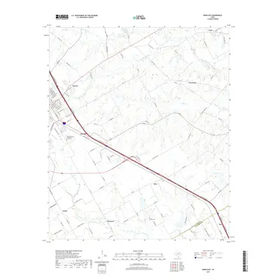
2019 Map of Ennis East
USGS Topo · Published 2019About this map
Ennis and the surrounding blackland prairies of eastern Ellis County are defined by a mix of established residential grids and expansive rural tracts. This corridor along Interstate 45 serves as a primary transit artery, connecting the larger hub of Ennis with smaller outlying communities like Alma, Rice, and Telico. The landscape is etched by a network of drainage systems, including Village Creek and Walker Creek, which have historically shaped the agricultural viability of the region. Local history is anchored by sites such as the IOOF Odd Fellows and Rebekahs Home Cemetery, while smaller settlements like Creechville and Oak Grove maintain their distinct positions within the local road network. The map reveals the precise layout of street names in eastern Ennis, from E Ennis Ave to Lake Bardwell Dr, alongside rural routes like Old Telico Road that once served as primary connectors before modern highway development.
Find a feature on this map
93 named features on this map. Tap any name to fly to it.
Don’t see what you’re looking for? This feature index may not catch every label — zoom into the map to look around manually.
Map Details
Editions of this 2019 Ennis East Map
This is the sole edition of this map. No revisions or reprints were ever made.
Other maps of this area

1954 · Dallas
USGS Topo · 1:250,000

1956 · Ennis
USGS Topo · 1:62,500

1958 · Dallas
USGS Topo · 1:250,000

1961 · Chatfield
USGS Topo · 1:24,000

1962 · Emhouse
USGS Topo · 1:24,000

1962 · Ennis West
USGS Topo · 1:24,000

1962 · Ennis East
USGS Topo · 1:24,000

1962 · Rosser SW
USGS Topo · 1:24,000

1962 · Cryer Creek
USGS Topo · 1:24,000
1962 · Bristol
USGS Topo · 1:24,000