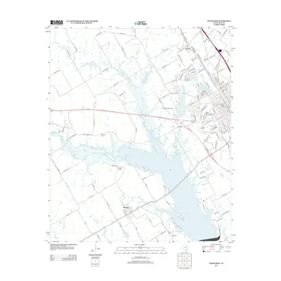
2012 Map of Ennis West
USGS Topo · Published 2012About this map
Bardwell Lake dominates the central landscape of this 2012 survey, its southern reach bounded by the town of Bardwell. This region of Ellis County exhibits a transition from established urban centers to vast agricultural expanses. In the northeast, the Ennis Commercial Historic District and Old City Mills represent the area's deep-rooted industrial and commercial heritage. The map is particularly useful for genealogists, as it documents several historic burial grounds including Boren Cem, Templeton Cem, and Sanderson Cem. Aviation history is also present, with both Ennis Municipal Airport and the private Flying O Airport serving the area. Waterways like Waxahachie Cr and Mustang Cr weave through the terrain, illustrating the natural drainage patterns that have historically supported local farming.
Find a feature on this map
132 named features on this map. Tap any name to fly to it.
Don’t see what you’re looking for? This feature index may not catch every label — zoom into the map to look around manually.
Map Details
Editions of this 2012 Ennis West Map
This is the sole edition of this map. No revisions or reprints were ever made.
Other maps of this area

1954 · Dallas
USGS Topo · 1:250,000

1956 · Ennis
USGS Topo · 1:62,500

1958 · Dallas
USGS Topo · 1:250,000

1961 · Forreston
USGS Topo · 1:24,000
1961 · Waxahachie
USGS Topo · 1:24,000

1962 · Emhouse
USGS Topo · 1:24,000

1962 · Ennis West
USGS Topo · 1:24,000

1962 · Ennis East
USGS Topo · 1:24,000

1962 · Cryer Creek
USGS Topo · 1:24,000
1962 · Bristol
USGS Topo · 1:24,000