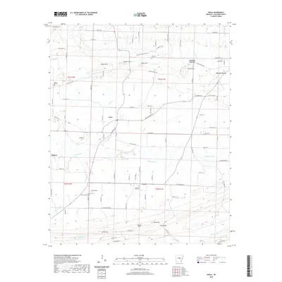
2020 Map of Enola
USGS Topo · Published 2020About this map
Enola and Holland sit within a landscape defined by the low, wooded ridges of the eastern Ozark foothills and the drainage network of Muddy Bayou. This survey of northeastern Faulkner County reveals a community structure centered on small settlements and rural intersections like Naylor and Garland Springs. The terrain is punctuated by distinct summits including Whitmore Mtn, Dalton Mtn, and Cascade Mtn, while the southern reaches are marked by natural passages such as Cascade Gap and Stanley Gap. Several family-named cemeteries, including Marcus Hill Cem and Heffington Cem, are distributed throughout the township, providing a clear record of local settlement patterns. Small water bodies like Nalholz Lake and creeks such as Turkey Cr and Caney Cr wind through the valleys, reflecting the area's agricultural and pastoral character. The road network, including State HWY 310 and MT Vernon RD, connects these outlying homes and landmarks to the larger rural hub of Mount Vernon.
Find a feature on this map
68 named features on this map. Tap any name to fly to it.
Don’t see what you’re looking for? This feature index may not catch every label — zoom into the map to look around manually.
Map Details
Editions of this 2020 Enola Map
This is the sole edition of this map. No revisions or reprints were ever made.
Other maps of this area

1956 · Russellville
USGS Topo · 1:250,000

1961 · Conway
USGS Topo · 1:62,500

1961 · Bee Branch
USGS Topo · 1:62,500

1961 · Guy
USGS Topo · 1:24,000
1961 · Holland
USGS Topo · 1:24,000
1961 · Hamlet
USGS Topo · 1:24,000

1963 · Rose Bud
USGS Topo · 1:24,000

1963 · Enola
USGS Topo · 1:24,000

1963 · Mount Vernon
USGS Topo · 1:24,000
1963 · Mountain Springs
USGS Topo · 1:24,000