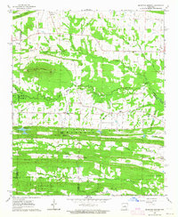
1963 Map of Mountain Springs
USGS Topo · Published 1964About this map
The community of Mountain Springs serves as the focal point of this 1963 survey, situated along the complex borders of White, Lonoke, and Faulkner counties. The landscape is defined by the east-west orientation of Lewisburg Ridge and Magness Hill, which separate the northern drainage of Little Cypress Creek from the southern reaches of Fourmile Creek. This topography influenced the placement of early rural hubs such as El Paso and Opal, while the interior terrain is dotted with ancestral landmarks like the Shurley Cem and Grizzard Cem.
Find a feature on this map
48 named features on this map. Tap any name to fly to it.
Don’t see what you’re looking for? This feature index may not catch every label — zoom into the map to look around manually.
Map Details
Editions of this 1963 Mountain Springs Map
3 editions found
Other maps of this area

1891 · Little Rock
USGS Topo · 1:125,000

1893 · Little Rock
USGS Topo · 1:125,000

1940 · Lonoke
USGS Topo · 1:62,500

1941 · Olmstead
USGS Topo · 1:31,680

1941 · Cabot
USGS Topo · 1:31,680

1948 · Helena
USGS Topo · 1:250,000

1949 · Lonoke
USGS Topo · 1:62,500

1950 · Helena
USGS Topo · 1:250,000

1950 · Lonoke
USGS Topo · 1:62,500

1953 · Memphis
USGS Topo · 1:250,000