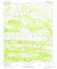
1963 Map of Mountain Springs
USGS Topo · Published 1976About this map
Magness Ridge and Lewisburg Ridge dominate the central landscape of this Arkansas survey, defining a series of gaps and hills that shaped local settlement and transport. The community of Mountain Springs sits at the foot of these elevations, where numerous small creeks like Magness Creek and Fourmile Creek drain the surrounding slopes. The map reveals a high density of rural religious and burial sites, including the Rock Hill Cem Magness Chapel and Sixteenth Section Ch, which served established farming families across the El Paso and Royal districts. To the north, the terrain transitions toward Round Mountain, where distinct markings for Quarries and Mines indicate local extractive industries. The presence of Landing Strip and photorevised updates from the mid-1970s illustrate the early modernizing of these traditional agricultural and timber lands near the county borders.
Find a feature on this map
59 named features on this map. Tap any name to fly to it.
Don’t see what you’re looking for? This feature index may not catch every label — zoom into the map to look around manually.
Map Details
Editions of this 1963 Mountain Springs Map
3 editions found
Other maps of this area

1891 · Little Rock
USGS Topo · 1:125,000

1893 · Little Rock
USGS Topo · 1:125,000

1940 · Lonoke
USGS Topo · 1:62,500

1941 · Olmstead
USGS Topo · 1:31,680

1941 · Cabot
USGS Topo · 1:31,680

1948 · Helena
USGS Topo · 1:250,000

1949 · Lonoke
USGS Topo · 1:62,500

1950 · Helena
USGS Topo · 1:250,000

1950 · Lonoke
USGS Topo · 1:62,500

1953 · Memphis
USGS Topo · 1:250,000