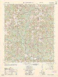
1962 Map of Enterprise NE
USGS Topo · Published 1962About this map
The Army Map Service documents a transition in the landscape of Coffee and Dale Counties as agrarian landmarks are absorbed by the Fort Rucker Military Reservation. Rural life is still visible through the presence of El Bethel Church, Old Tabernacle Church, and Wesley Chapel, alongside the family-named Ebenezer Cemetery. This 1962 edition highlights the intensification of military training infrastructure, with numerous specialized sites such as the 1000 Inch Firing Range, the Malone Firing Range, and the Helicopter ammunition loading area. The terrain is defined by a dense network of waterways, including Harris Mill (Bowles) Creek and Blocks Mill Creek, which cut through the restricted impact areas. A fire tower and various ruins suggest the older footprint of the area before its conversion to a permanent military installation.
Find a feature on this map
37 named features on this map. Tap any name to fly to it.
Don’t see what you’re looking for? This feature index may not catch every label — zoom into the map to look around manually.
Map Details
Editions of this 1962 Enterprise NE Map
This is the sole edition of this map. No revisions or reprints were ever made.
Other maps of this area

1942 · Enterprise
USGS Topo · 1:125,000

1948 · Ozark
USGS Topo · 1:62,500

1948 · Brundidge
USGS Topo · 1:62,500

1950 · Ozark
USGS Topo · 1:62,500

1950 · Enterprise
USGS Topo · 1:62,500

1950 · Brundidge
USGS Topo · 1:62,500

1953 · Dothan
USGS Topo · 1:250,000

1954 · Dothan
USGS Topo · 1:250,000

1955 · Dothan
USGS Topo · 1:250,000

1960 · Brundidge SE
USGS Topo · 1:24,000