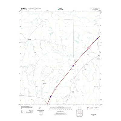
2011 Map of Epes West
USGS Topo · Published 2011About this map
Sumterville and the rural crossroads of McCainville anchor this portion of Sumter County, where the landscape is defined by the winding drainages of Shumulla Creek and Jones Creek. This 2011 topographic record reveals a territory marked by family landholdings and small community centers, connected by a network of historic routes like Hayes Ferry Rd and Hammer Sumterville Rd. The area is particularly significant for genealogical research, as it preserves the locations of numerous small burial grounds including the Eskeridge Pettigrew Cemetery, Henagan Cemetery, and Shiloh Cemetery. Near the eastern edge, the terrain shifts toward the settlement of Epes, while the central corridor is shaped by the passage of Cockerell Branch and Holetah Creek, illustrating the traditional agricultural and water-dependent settlement patterns of this Alabama Black Belt region.
Find a feature on this map
44 named features on this map. Tap any name to fly to it.
Don’t see what you’re looking for? This feature index may not catch every label — zoom into the map to look around manually.
Map Details
Editions of this 2011 Epes West Map
This is the sole edition of this map. No revisions or reprints were ever made.
Other maps of this area

1929 · Epes
USGS Topo · 1:48,000

1932 · Epes
USGS Topo · 1:62,500

1953 · Meridian
USGS Topo · 1:250,000

1957 · Meridian
USGS Topo · 1:250,000

1965 · Meridian
USGS Topo · 1:250,000
1970 · Boligee
USGS Topo · 1:24,000

1970 · Gainesville
USGS Topo · 1:24,000
1973 · Geiger
USGS Topo · 1:24,000

1974 · Boyd
USGS Topo · 1:24,000
1974 · Epes West
USGS Topo · 1:24,000