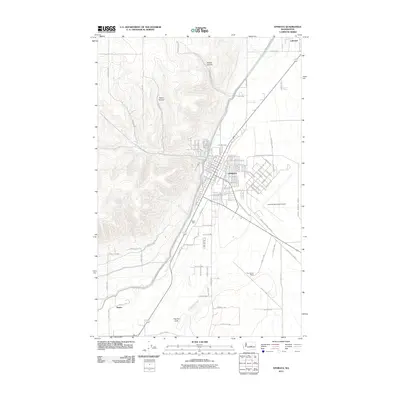
2011 Map of Ephrata
USGS Topo · Published 2011About this map
Ephrata serves as the primary hub of this landscape, situated at the base of the dramatic western hills. The town's grid expands toward the east, where the Ephrata Municipal Airport and industrial areas like Olson Spur reflect a long-standing connection to regional transport and logistics. To the west, the terrain rises sharply into the deep cuts of Hunter Canyon and Davis Canyon, showcasing the geological transition from the flat basin floor to the high plateau. To the south, agricultural and ranching patterns emerge around Drumheller Ranch and the small settlement of Naylor. The map reveals a highly structured environment defined by irrigation and infrastructure, noted by the presence of the Canal Maintenance Rd and the distinctive depression known as The Pot Hole, illustrating the complex management of water and land in this part of Grant County.
Find a feature on this map
130 named features on this map. Tap any name to fly to it.
Don’t see what you’re looking for? This feature index may not catch every label — zoom into the map to look around manually.
Map Details
Editions of this 2011 Ephrata Map
This is the sole edition of this map. No revisions or reprints were ever made.
Other maps of this area

1910 · Winchester
USGS Topo · 1:62,500

1912 · Moses Lake
USGS Topo · 1:62,500

1953 · Ritzville
USGS Topo · 1:250,000

1956 · Ephrata
USGS Topo · 1:62,500

1956 · Ephrata
USGS Topo · 1:24,000

1956 · Ephrata SW
USGS Topo · 1:24,000

1956 · Grant Orchards
USGS Topo · 1:24,000

1956 · Winchester NE
USGS Topo · 1:24,000
1956 · Moses Lake NW
USGS Topo · 1:24,000

1956 · Soap Lake
USGS Topo · 1:24,000