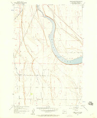
1956 Map of Moses Lake NW
USGS Topo · Published 1957About this map
Moses Lake dominates the central portion of this mid-1950s landscape, serving as a primary hydrological focal point in Grant County. The topography reveals an era of significant transition, specifically through the extensive irrigation infrastructure marked as Canal Under Construction and several other completed Canal segments. This engineering reflects the region's mid-century shift toward large-scale agricultural development. The terrain is defined by broad depressions including Hiawatha Valley and Mae Valley, while the northern reaches show Rocky Ford feeding into the main lake basin. Transportation is primarily represented by the established White Trail Road and various pipelines. Numerous wells are scattered across the valley floors, highlighting the critical role of groundwater and managed water systems in sustaining this arid landscape just as it was being transformed for modern farming.
Find a feature on this map
13 named features on this map. Tap any name to fly to it.
Don’t see what you’re looking for? This feature index may not catch every label — zoom into the map to look around manually.
Map Details
Editions of this 1956 Moses Lake NW Map
3 editions found
Other maps of this area

1910 · Winchester
USGS Topo · 1:62,500

1912 · Moses Lake
USGS Topo · 1:62,500

1953 · Ritzville
USGS Topo · 1:250,000

1956 · Ephrata
USGS Topo · 1:62,500

1956 · Moses Lake South
USGS Topo · 1:24,000

1956 · Ephrata
USGS Topo · 1:24,000

1956 · Grant Orchards
USGS Topo · 1:24,000

1956 · Moses Lake North
USGS Topo · 1:24,000

1956 · Gloyd
USGS Topo · 1:24,000

1956 · Mae
USGS Topo · 1:24,000