
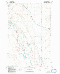
1956 Map of Gloyd
USGS Topo · Published 1957About this map
Gloyd sits at the heart of this mid-century irrigation landscape, where the Northern Pacific railroad cuts a diagonal line across the basalt coulees and scrubland. The map documents the extensive water engineering projects of the Columbia Basin, defined by the massive East Low Canal Levee and a network of siphons and spoil banks. This infrastructure radically altered the arid terrain around Crab Creek, facilitating the transition to intensive agriculture. Scattered water features like Willow Lake, South Willow Lake, and various unnamed Springs reflect the local hydrology before and during the expansion of the canal system. The Moses Lake - Stratford Road provides the primary north-south transit corridor, linking the small settlement of Gloyd to the broader regional economy during a period of significant technological and environmental transformation.
Find a feature on this map
12 named features on this map. Tap any name to fly to it.
Don’t see what you’re looking for? This feature index may not catch every label — zoom into the map to look around manually.
Map Details
Editions of this 1956 Gloyd Map
2 editions found
Other maps of this area

1912 · Moses Lake
USGS Topo · 1:62,500

1923 · Wheeler
USGS Topo · 1:62,500

1925 · Wheeler
USGS Topo · 1:62,500

1953 · Ritzville
USGS Topo · 1:250,000

1956 · Wheeler
USGS Topo · 1:24,000

1956 · Stratford
USGS Topo · 1:24,000

1956 · Grant Orchards
USGS Topo · 1:24,000

1956 · Moses Lake North
USGS Topo · 1:24,000

1956 · Wilson Creek SW
USGS Topo · 1:24,000

1956 · Wilson Creek NW
USGS Topo · 1:24,000