
1956 Map of Wilson Creek SW
USGS Topo · Published 1957About this map
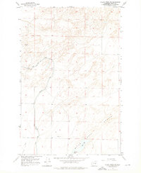
The intricate hydraulic systems of the mid-century Columbia Basin Project dominate this 1956 landscape in Grant County. The Low East Canal cuts through the western sections, accompanied by engineering features such as a Siphon, a significant Levee, and a prominent Spoil Bank. These features reflect the post-war transformation of the arid Washington interior into irrigated farmland. In the southern portion of the quadrangle, water collects in Black Lake and Artesian Lake, which sit at the base of the dramatic Rock Coulee landform. Evidence of local habitation and industry is sparse but present, including the settlement of Olson and a nearby Barrow Pit, providing a clear record of the area's transition toward modern agricultural infrastructure.
Find a feature on this map
11 named features on this map. Tap any name to fly to it.
Don’t see what you’re looking for? This feature index may not catch every label — zoom into the map to look around manually.
Map Details
Editions of this 1956 Wilson Creek SW Map
2 editions found
Other maps of this area

1912 · Moses Lake
USGS Topo · 1:62,500

1923 · Wheeler
USGS Topo · 1:62,500

1925 · Wheeler
USGS Topo · 1:62,500

1953 · Ritzville
USGS Topo · 1:250,000

1956 · Wheeler
USGS Topo · 1:24,000

1956 · Stratford
USGS Topo · 1:24,000

1956 · Moses Lake North
USGS Topo · 1:24,000

1956 · Gloyd
USGS Topo · 1:24,000

1956 · Wheeler NE
USGS Topo · 1:24,000

1956 · Wilson Creek SE
USGS Topo · 1:24,000