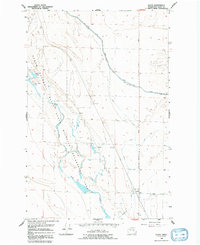
1956 Map of Gloyd
USGS Topo · Published 1992About this map
The settlement of Gloyd stands as a focal point in this mid-century landscape of Grant County, where the transition between natural wetlands and industrial irrigation is clearly visible. The Columbia Basin State Wildlife Recreation Area dominates the western portion of the map, protecting the complex hydrology of Crab Creek and its associated water bodies like Willow Lake and South Willow Lake. These features reveal the area's significance as a habitat for waterfowl and wildlife in the otherwise arid interior.
Find a feature on this map
12 named features on this map. Tap any name to fly to it.
Don’t see what you’re looking for? This feature index may not catch every label — zoom into the map to look around manually.
Map Details
Editions of this 1956 Gloyd Map
2 editions found
Other maps of this area

1912 · Moses Lake
USGS Topo · 1:62,500

1923 · Wheeler
USGS Topo · 1:62,500

1925 · Wheeler
USGS Topo · 1:62,500

1953 · Ritzville
USGS Topo · 1:250,000

1956 · Wheeler
USGS Topo · 1:24,000

1956 · Stratford
USGS Topo · 1:24,000

1956 · Grant Orchards
USGS Topo · 1:24,000

1956 · Moses Lake North
USGS Topo · 1:24,000

1956 · Gloyd
USGS Topo · 1:24,000

1956 · Wilson Creek SW
USGS Topo · 1:24,000