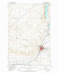
1956 Map of Ephrata
USGS Topo · Published 1966About this map
Beezley Hills dominate the southern landscape of this mid-century survey, rising above the expanding city of Ephrata. The map documents a critical period of infrastructure growth in Grant County, showing the intricate path of the West Canal as it snakes through the region to support local agriculture. The northern reach is defined by the saline waters of Soap Lake and the southern tip of Lake Lenore, while the dry expanses of Sagebrush Flat reveal the transition from open range to organized settlement. Institutional footprints are clearly marked, from the Ephrata Municipal Airport and Olson Spur to local educational landmarks like Columbia Ridge School and the already defunct Wheatland School (Aband). This topography illustrates the intersection of natural basalt coulee formations and the engineering required to bring water and rail to the high desert.
Find a feature on this map
29 named features on this map. Tap any name to fly to it.
Don’t see what you’re looking for? This feature index may not catch every label — zoom into the map to look around manually.
Map Details
Editions of this 1956 Ephrata Map
2 editions found
Other maps of this area

1909 · Quincy
USGS Topo · 1:62,500

1910 · Quincy
USGS Topo · 1:62,500

1910 · Winchester
USGS Topo · 1:62,500

1912 · Moses Lake
USGS Topo · 1:62,500

1953 · Ritzville
USGS Topo · 1:250,000

1956 · Ephrata
USGS Topo · 1:62,500

1956 · Ephrata
USGS Topo · 1:24,000

1956 · Ephrata SW
USGS Topo · 1:24,000

1956 · Grant Orchards
USGS Topo · 1:24,000

1956 · Winchester NE
USGS Topo · 1:24,000