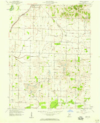
1957 Map of Epsom
USGS Topo · Published 1958About this map
The White River defines the northwest corner of this Daviess County landscape, where the flat plains of the Elmore and Bogard townships meet an evolving industrial environment. The mid-century economy of Epsom is clearly shaped by the presence of several Strip Mine operations and scattered Oil Wells, contrasting with the traditional rural network of country churches and family cemeteries. Significant rail infrastructure facilitates these industries, with the Chicago Milwaukee St Paul and Pacific and the New York Central crossing the territory. Water management is evident through a complex system of drainage, including Kane Ditch and the Lateral Ditch, which channel water toward Smothers Creek and the North Fork Prairie Creek. For those tracing local roots, the map provides precise locations for several burial grounds, such as Tolberts Chapel Cem and Ochiltree Cem, alongside the small settlements of Elnora and Cornettsville.
Find a feature on this map
34 named features on this map. Tap any name to fly to it.
Don’t see what you’re looking for? This feature index may not catch every label — zoom into the map to look around manually.
Map Details
Editions of this 1957 Epsom Map
This is the sole edition of this map. No revisions or reprints were ever made.
Other maps of this area

1943 · Lyons
USGS Topo · 1:24,000

1943 · Sandborn
USGS Topo · 1:24,000

1943 · Plainville
USGS Topo · 1:24,000

1943 · Epsom
USGS Topo · 1:24,000

1944 · Montgomery
USGS Topo · 1:24,000

1944 · Washington
USGS Topo · 1:24,000

1950 · Odon
USGS Topo · 1:24,000

1956 · Loogootee
USGS Topo · 1:24,000

1956 · Vincennes
USGS Topo · 1:250,000

1957 · Vincennes
USGS Topo · 1:250,000