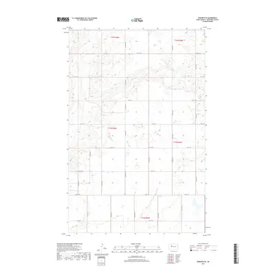
2017 Map of Epworth SE
USGS Topo · Published 2017About this map
Shell Cr meanders through the northern sections of this rural landscape in Mountrail County, defining the drainage patterns of this prairie region. The area is heavily defined by the Public Land Survey System, with townships such as t154n r89w and t153n r88w organizing the terrain into a disciplined grid of sections. This geometric layout is reflected in the local road network, which consists almost entirely of numbered section-line roads such as 48th St NW and 71st Ave NW. This mapping shows the intersection of natural watercourses and the rigid human imposition of boundaries on the North Dakota plains. The numerous small depressions and wetland signatures across the central sections suggest the glacial pothole character common to this part of the state, where agriculture must navigate between water-filled basins and low rises.
Find a feature on this map
27 named features on this map. Tap any name to fly to it.
Don’t see what you’re looking for? This feature index may not catch every label — zoom into the map to look around manually.
Map Details
Editions of this 2017 Epworth SE Map
This is the sole edition of this map. No revisions or reprints were ever made.
Other maps of this area

1953 · Williston
USGS Topo · 1:250,000
1953 · Watford City
USGS Topo · 1:250,000
1954 · Minot
USGS Topo · 1:250,000
1954 · McClusky
USGS Topo · 1:250,000

1957 · Williston
USGS Topo · 1:250,000
1957 · Watford City
USGS Topo · 1:250,000
1958 · McClusky
USGS Topo · 1:250,000
1958 · Minot
USGS Topo · 1:250,000
1967 · Watford City
USGS Topo · 1:250,000
1980 · Minot
USGS Topo · 1:100,000