
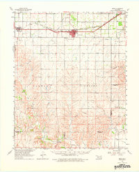
1961 Map of Erick
USGS Topo · Published 1963About this map
The Chicago Rock Island and Pacific railroad forms the industrial spine of this Beckham County landscape, connecting the agricultural hubs of Erick and Texola along the Texas-Oklahoma border. In the early 1960s, Erick served as a prominent local center, featuring a concentrated grid with a Drive-in Theater, Hospital, and Haddock Airport nearby. The terrain transitions from the developed rail corridor in the north to the dissected drainage systems of the Elm Fork Red River in the south, where the Gaging Station and Salt Works indicate the river's importance to the local economy and environment. Genealogists can locate several rural burial sites, including Munnerson Cem, Davis Cem, and Texola Cem. The map captures a moment of mid-century infrastructure, balancing the established rail network with the emerging presence of decentralized rural landmarks and river-based industry.
Find a feature on this map
39 named features on this map. Tap any name to fly to it.
Don’t see what you’re looking for? This feature index may not catch every label — zoom into the map to look around manually.
Map Details
Editions of this 1961 Erick Map
2 editions found
Other maps of this area

1954 · Amarillo
USGS Topo · 1:250,000

1954 · Plainview
USGS Topo · 1:250,000

1955 · Lawton
USGS Topo · 1:250,000

1955 · Clinton
USGS Topo · 1:250,000

1957 · Clinton
USGS Topo · 1:250,000

1958 · Amarillo
USGS Topo · 1:250,000

1958 · Plainview
USGS Topo · 1:250,000

1959 · Shinnery Creek
USGS Topo · 1:24,000

1960 · Sweetwater
USGS Topo · 1:62,500

1960 · Sayre
USGS Topo · 1:62,500