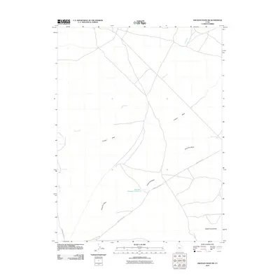
2010 Map of Erickson Wash SW
USGS Topo · Published 2010About this map
Desert Mountain anchor the southeastern corner of this remote Juab County landscape, where ancient drainage patterns are still clearly visible in the desert floor. The dominant feature of the quadrangle is the winding course of the Old River Bed, a significant geological trace of the prehistoric Lake Bonneville drainage system. At the heart of this arid basin lies River Bed Reservoir Number 2, a vital water management point for local ranching operations. The terrain is defined by a series of significant washes, including Erickson Wash, South Pine Wash, and the seasonally active Judd Creek. Transportation through this vast open country is facilitated by the Jericho Callao Rd and Riverbed Ranch Rd, providing access to isolated points like the Meadow Creek Well.
Find a feature on this map
9 named features on this map. Tap any name to fly to it.
Don’t see what you’re looking for? This feature index may not catch every label — zoom into the map to look around manually.
Map Details
Editions of this 2010 Erickson Wash SW Map
This is the sole edition of this map. No revisions or reprints were ever made.
Other maps of this area

1885 · Sevier Desert
USGS Topo · 1:250,000

1953 · Delta
USGS Topo · 1:250,000

1955 · Indian Springs
USGS Topo · 1:24,000

1955 · Coyote Springs
USGS Topo · 1:24,000

1958 · Delta
USGS Topo · 1:250,000

1962 · Delta
USGS Topo · 1:250,000
1971 · Erickson Knoll
USGS Topo · 1:24,000

1971 · Desert Mtn Pass
USGS Topo · 1:24,000

1971 · Crater Bench Reservoir
USGS Topo · 1:24,000
1971 · Keg Mtn Ranch
USGS Topo · 1:24,000