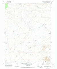
1971 Map of Erickson Wash SW
USGS Topo · Published 1974About this map
Desert Mountain dominates the southeast corner of this arid landscape, serving as a landmark for early 1970s mining and ranching interests in this corner of Juab County. The topography is defined by ancient drainage patterns, most notably the Old River Bed and the extensive network of Erickson Wash and Judd Creek that cut through the desert flats. Human activity is evidenced by scattered infrastructure tailored for survival and extraction, including River Bed Reservoir No 2 and several vital water sources like Meadow Creek Well and Well No 18. Small-scale mineral exploration is visible on the slopes of the mountain, where a Mine and several Prospects are recorded alongside a network of Jeep Trails that provided the primary means of navigating this remote basin floor.
Find a feature on this map
15 named features on this map. Tap any name to fly to it.
Don’t see what you’re looking for? This feature index may not catch every label — zoom into the map to look around manually.
Map Details
Editions of this 1971 Erickson Wash SW Map
This is the sole edition of this map. No revisions or reprints were ever made.
Other maps of this area

1885 · Sevier Desert
USGS Topo · 1:250,000

1953 · Delta
USGS Topo · 1:250,000

1955 · Indian Springs
USGS Topo · 1:24,000

1955 · Coyote Springs
USGS Topo · 1:24,000

1958 · Delta
USGS Topo · 1:250,000

1962 · Delta
USGS Topo · 1:250,000
1971 · Erickson Knoll
USGS Topo · 1:24,000

1971 · Desert Mtn Pass
USGS Topo · 1:24,000

1971 · Crater Bench Reservoir
USGS Topo · 1:24,000
1971 · Keg Mtn Ranch
USGS Topo · 1:24,000