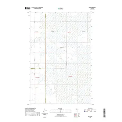
2019 Map of Erie NE
USGS Topo · Published 2019About this map
The remote northern landscape of Beltrami, Marshall, and Pennington counties is defined by an extensive wetland network and a sparse, grid-like road system. In this rural pocket of Minnesota, the map reveals the intersection of three county lines, where Reservation Rd 24 and Thorhult Rd Nw provide rare access through the marshy terrain. The presence of Log Church Rd Nw in the northeastern corner suggests localized cultural landmarks even in this thinly populated region. The infrastructure is primarily oriented around essential county connectors like Co Hwy 64 and several numbered township roads. The topographic data highlights the extreme flatness and drainage patterns of the area, typical of the glacial lake plains in the Red River Valley hinterlands.
Find a feature on this map
24 named features on this map. Tap any name to fly to it.
Don’t see what you’re looking for? This feature index may not catch every label — zoom into the map to look around manually.
Map Details
Editions of this 2019 Erie NE Map
This is the sole edition of this map. No revisions or reprints were ever made.
Other maps of this area
1918 · Malcolm
USGS Topo · 1:62,500
1918 · Jelle
USGS Topo · 1:62,500
1919 · Liner
USGS Topo · 1:62,500

1954 · Roseau
USGS Topo · 1:250,000

1957 · Roseau
USGS Topo · 1:250,000

1958 · Roseau
USGS Topo · 1:250,000
1972 · Erie
USGS Topo · 1:24,000
1972 · Good Lake
USGS Topo · 1:24,000
1973 · Grygla
USGS Topo · 1:24,000
1973 · Grygla SW
USGS Topo · 1:24,000