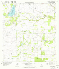
1979 Map of Escondido Lake
USGS Topo · Published 1979About this map
Escondido Lake and the surrounding ranchlands of Kleberg County are defined by a network of ephemeral creeks and a reliance on subterranean water. In this late 1970s landscape, the infrastructure of the cattle industry is visible through numerous named water sources such as Santa Gertrudis Windmill, Monte Verde Windmill, and Pita Windmill. The terrain is crisscrossed by drainage patterns including Jaboncillos Creek, Escondido Creek, and Derramadero de Machos Creek, which feed into localized basins like Zaino Lake. This period also reflects the region's energy development, with scattered Oil Wells and specific sites like the Media Luna Well and Chappa Well punctuating the open range. Near the eastern edge, the Rest Haven Memorial Park (Cem) and a Radio Facility represent the modern expansion of human activity into this traditional ranching territory.
Find a feature on this map
27 named features on this map. Tap any name to fly to it.
Don’t see what you’re looking for? This feature index may not catch every label — zoom into the map to look around manually.
Map Details
Editions of this 1979 Escondido Lake Map
This is the sole edition of this map. No revisions or reprints were ever made.
Other maps of this area

1917 · Ben Bolt
USGS Topo · 1:62,500

1921 · Falfurrias
USGS Topo · 1:125,000

1928 · Sarita
USGS Topo · 1:125,000

1950 · Corpus Christi
USGS Topo · 1:250,000

1954 · Kingsville
USGS Topo · 1:62,500

1954 · Riviera
USGS Topo · 1:62,500

1956 · Corpus Christi
USGS Topo · 1:250,000

1956 · Laredo
USGS Topo · 1:250,000

1960 · Corpus Christi
USGS Topo · 1:250,000

1963 · Ben Bolt SE
USGS Topo · 1:24,000