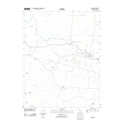
2012 Map of Esparto
USGS Topo · Published 2012About this map
Esparto serves as a primary settlement node in this 2012 survey, situated where the valley floor begins its ascent into the foothill terrain of Yolo County. The landscape is defined by the drainage patterns of Cache Cr and a series of sloughs, including Lamb Valley Slough and Cottonwood Slough, which weave through the agricultural flats and low-lying valleys. The transition from the flat agricultural lands of the Capay Valley to the more varied topography of Canterbury Mountain and Sugarloaf reveals a complex network of canyons and flats, such as Pipeline Canyon and Lindermans Flat. For those tracing local history, the map provides precise locations for the Capay Cem and various named points of interest like Horsehead Gate and Turkey Camp. The grid of county roads, such as Co RD 87 and Co RD 23, illustrates the modern land use and connectivity between the scattered ranches and the central hubs of Capay and Esparto.
Find a feature on this map
50 named features on this map. Tap any name to fly to it.
Don’t see what you’re looking for? This feature index may not catch every label — zoom into the map to look around manually.
Map Details
Editions of this 2012 Esparto Map
This is the sole edition of this map. No revisions or reprints were ever made.
Other maps of this area

1905 · Esparto
USGS Topo · 1:24,000

1907 · Dunnigan
USGS Topo · 1:62,500

1907 · Woodland
USGS Topo · 1:62,500

1916 · Jacobs Corner
USGS Topo · 1:31,680

1916 · Zamora
USGS Topo · 1:31,680

1916 · Winters
USGS Topo · 1:31,680

1916 · Esparto
USGS Topo · 1:31,680

1924 · Capay
USGS Topo · 1:62,500
1941 · Dunnigan
USGS Topo · 1:62,500
1941 · Woodland
USGS Topo · 1:62,500