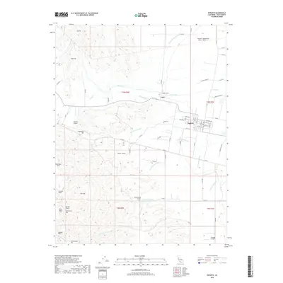
2018 Map of Esparto
USGS Topo · Published 2018About this map
The Capay Valley opens into the western edge of the Sacramento Valley, where the town of Esparto serves as a hub for the surrounding agricultural plains of Yolo County. Water management is a central theme of this landscape, with the Hungry Hollow Canal, Winters Canal, and Townsend Drain redirecting flows across the flatlands while Cache Creek winds through the northern portion. The transition from the valley floor to the western uplands is marked by significant topographical landmarks such as Sugarloaf, Canterbury Mtn, and Jackson Bluffs. Genealogists and local researchers can locate the Capay Cem situated between the settlements of Capay and Esparto. The map detail extends to specific named canyons and flats in the western hills, including Parker Canyon, Cottonwood Canyon, and Lindermans Flat, illustrating the complex drainage systems like Lamb Valley Slough that feed toward the central valley.
Find a feature on this map
72 named features on this map. Tap any name to fly to it.
Don’t see what you’re looking for? This feature index may not catch every label — zoom into the map to look around manually.
Map Details
Editions of this 2018 Esparto Map
This is the sole edition of this map. No revisions or reprints were ever made.
Other maps of this area

1905 · Esparto
USGS Topo · 1:24,000

1907 · Dunnigan
USGS Topo · 1:62,500

1907 · Woodland
USGS Topo · 1:62,500

1916 · Jacobs Corner
USGS Topo · 1:31,680

1916 · Zamora
USGS Topo · 1:31,680

1916 · Winters
USGS Topo · 1:31,680

1916 · Esparto
USGS Topo · 1:31,680

1924 · Capay
USGS Topo · 1:62,500
1941 · Dunnigan
USGS Topo · 1:62,500
1941 · Woodland
USGS Topo · 1:62,500