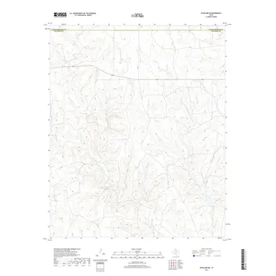
2019 Map of Estelline NE
USGS Topo · Published 2019About this map
Collingsworth County and Childress County meet along an intricate drainage network in this section of the Texas Panhandle. The landscape is defined by the highly dissected terrain surrounding Wet Salt Creek and its tributaries, including Dry Salt Creek and Salt Creek. This topography indicates a complex erosion pattern typical of the region's semi-arid plains, where seasonal water flow carves deep, winding draws into the earth. Human imprint is minimal across this rural expanse, primarily limited to a few secondary thoroughfares like Highway 256 and local routes such as Co RD 7. The map illustrates the dominance of the Horse Creek drainage system, showing how these narrow watercourses dictate the local geography and restrict development to the higher, flatter ground between the creek beds.
Find a feature on this map
7 named features on this map. Tap any name to fly to it.
Don’t see what you’re looking for? This feature index may not catch every label — zoom into the map to look around manually.
Map Details
Editions of this 2019 Estelline NE Map
This is the sole edition of this map. No revisions or reprints were ever made.
Other maps of this area

1954 · Plainview
USGS Topo · 1:250,000

1958 · Plainview
USGS Topo · 1:250,000

1960 · Loco
USGS Topo · 1:62,500

1961 · Estelline
USGS Topo · 1:62,500

1964 · Rolla SW
USGS Topo · 1:24,000

1964 · Wellington
USGS Topo · 1:24,000

1964 · Rolla
USGS Topo · 1:24,000

1984 · Estelline NE
USGS Topo · 1:24,000
1984 · Loco
USGS Topo · 1:24,000
1984 · Estelline NW
USGS Topo · 1:24,000