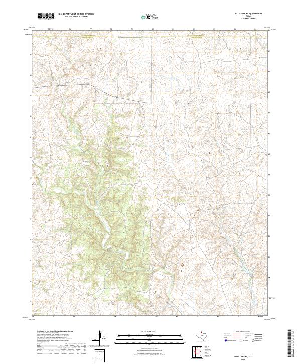
2022 Map of Estelline NE
USGS Topo · Published 2022About this map
Collingsworth and Childress counties meet in this dissected landscape of the Texas Panhandle, defined by an intricate network of drainage channels. The terrain is dominated by the winding paths of Wet Salt Cr, Dry Salt Cr, and Salt Cr, which carve through the plains to create a complex topographical relief. This area represents the rural transition between the high plains and the rolling red bed country, where water sources have historically dictated land use and property boundaries. Man-made imprints are sparse in this portion of the county, primarily limited to the passage of State Highway 256 and Co Rd 7. On the eastern side of the quadrangle, Horse Cr and Horse Creek contribute to the hydrologic pattern, illustrating the primary natural features that characterize this corner of the Panhandle.
Find a feature on this map
8 named features on this map. Tap any name to fly to it.
Don’t see what you’re looking for? This feature index may not catch every label — zoom into the map to look around manually.
Map Details
Editions of this 2022 Estelline NE Map
This is the sole edition of this map. No revisions or reprints were ever made.
Other maps of this area

1954 · Plainview
USGS Topo · 1:250,000

1958 · Plainview
USGS Topo · 1:250,000

1960 · Loco
USGS Topo · 1:62,500

1961 · Estelline
USGS Topo · 1:62,500

1964 · Rolla SW
USGS Topo · 1:24,000

1964 · Wellington
USGS Topo · 1:24,000

1964 · Rolla
USGS Topo · 1:24,000

1984 · Estelline NE
USGS Topo · 1:24,000
1984 · Loco
USGS Topo · 1:24,000
1984 · Estelline NW
USGS Topo · 1:24,000