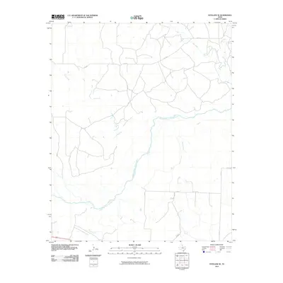
2010 Map of Estelline SE
USGS Topo · Published 2010About this map
The Prairie Dog Town Fork Red River meanders across this Childress County landscape, defining the local geography through its wide, shifting path. This 2010 survey illustrates a sparsely populated region of the Texas Panhandle, where water sources like Jonah Creek and Grassy Creek dictate the layout of rural access roads. The network of county routes, including Co RD K and Co RD 8, provides the primary infrastructure for ranching and agricultural operations. To the south, FM 2465 serves as a more significant corridor, while smaller tributaries such as Salt Creek and Baylor Creek drain the surrounding plains. The map reflects a modern era of land management where traditional rural roads maintain their importance in navigating the river's extensive floodplain.
Find a feature on this map
12 named features on this map. Tap any name to fly to it.
Don’t see what you’re looking for? This feature index may not catch every label — zoom into the map to look around manually.
Map Details
Editions of this 2010 Estelline SE Map
This is the sole edition of this map. No revisions or reprints were ever made.
Other maps of this area

1954 · Plainview
USGS Topo · 1:250,000

1958 · Plainview
USGS Topo · 1:250,000

1960 · Loco
USGS Topo · 1:62,500

1961 · Estelline
USGS Topo · 1:62,500

1967 · Tell North
USGS Topo · 1:24,000

1967 · Childress
USGS Topo · 1:24,000

1967 · Carey
USGS Topo · 1:24,000

1984 · Estelline NE
USGS Topo · 1:24,000
1984 · Loco
USGS Topo · 1:24,000
1984 · Estelline NW
USGS Topo · 1:24,000