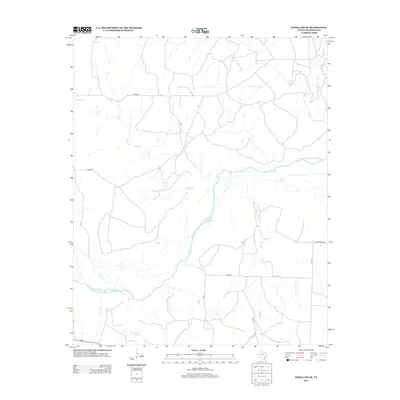
2013 Map of Estelline SE
USGS Topo · Published 2013About this map
The Prairie Dog Town Fork Red River carves a winding path through this corner of Childress County, defining the drainage patterns for a network of intermittent creeks. In this rural Texas Panhandle landscape, water sources like Jonah Cr, Salt Cr, and Grassy Cr dictate the layout of the land, with several watercourses branching out toward the eastern and southern margins. The area is marked by a sparse but regular grid of local transit routes, including Co Road K and Co Road P, which serve the agricultural and ranching tracts between the river and the northern reaches of Baylor Cr. This map illustrates the intersection of natural hydrology and modern land management, where established corridors like Ranch Road 2465 provide the primary connections through the open terrain.
Find a feature on this map
13 named features on this map. Tap any name to fly to it.
Don’t see what you’re looking for? This feature index may not catch every label — zoom into the map to look around manually.
Map Details
Editions of this 2013 Estelline SE Map
This is the sole edition of this map. No revisions or reprints were ever made.
Other maps of this area

1954 · Plainview
USGS Topo · 1:250,000

1958 · Plainview
USGS Topo · 1:250,000

1960 · Loco
USGS Topo · 1:62,500

1961 · Estelline
USGS Topo · 1:62,500

1967 · Tell North
USGS Topo · 1:24,000

1967 · Childress
USGS Topo · 1:24,000

1967 · Carey
USGS Topo · 1:24,000

1984 · Estelline NE
USGS Topo · 1:24,000
1984 · Loco
USGS Topo · 1:24,000
1984 · Estelline NW
USGS Topo · 1:24,000