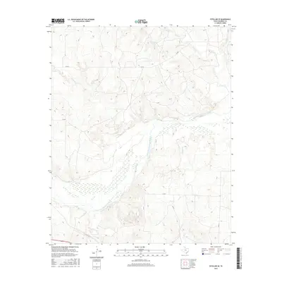
2016 Map of Estelline SE
USGS Topo · Published 2016About this map
The Prairie Dog Town Fork Red River dominates this portion of the Texas Panhandle, carving a wide, braided path through the landscape of Childress County. This 2016 survey highlights the intricate drainage network of the region, where tributaries like Salt Cr, Jonah Cr, and Grassy Cr cut through the elevation before joining the larger river system. The map reflects a predominantly rural and agricultural setting, defined by a sparse grid of local roads including Co RD K and Co RD 7. The presence of Baylor Cr and Horse Cr further illustrates the hydrological patterns essential to this semi-arid environment. This topographical study provides researchers with a clear view of the modern land divisions and water courses as they existed in the mid-2010s.
Find a feature on this map
12 named features on this map. Tap any name to fly to it.
Don’t see what you’re looking for? This feature index may not catch every label — zoom into the map to look around manually.
Map Details
Editions of this 2016 Estelline SE Map
This is the sole edition of this map. No revisions or reprints were ever made.
Other maps of this area

1954 · Plainview
USGS Topo · 1:250,000

1958 · Plainview
USGS Topo · 1:250,000

1960 · Loco
USGS Topo · 1:62,500

1961 · Estelline
USGS Topo · 1:62,500

1967 · Tell North
USGS Topo · 1:24,000

1967 · Childress
USGS Topo · 1:24,000

1967 · Carey
USGS Topo · 1:24,000

1984 · Estelline NE
USGS Topo · 1:24,000
1984 · Loco
USGS Topo · 1:24,000
1984 · Estelline NW
USGS Topo · 1:24,000