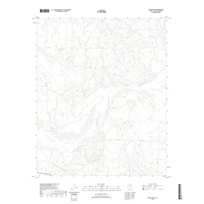
2019 Map of Estelline SE
USGS Topo · Published 2019About this map
The Prairie Dog Town Fork Red River dominates this portion of Childress County, carving a wide, braided path through the Texas Panhandle. This 2019 survey illustrates a landscape primarily shaped by its drainage systems, where several seasonal creeks like Salt Cr, Jonah Cr, and Horse Cr feed into the river valley. The topography is marked by the erosion typical of this region, with the riverbed itself showing the characteristic wide, sandy expanses of the Red River’s upper reaches.
Find a feature on this map
12 named features on this map. Tap any name to fly to it.
Don’t see what you’re looking for? This feature index may not catch every label — zoom into the map to look around manually.
Map Details
Editions of this 2019 Estelline SE Map
This is the sole edition of this map. No revisions or reprints were ever made.
Other maps of this area

1954 · Plainview
USGS Topo · 1:250,000

1958 · Plainview
USGS Topo · 1:250,000

1960 · Loco
USGS Topo · 1:62,500

1961 · Estelline
USGS Topo · 1:62,500

1967 · Tell North
USGS Topo · 1:24,000

1967 · Childress
USGS Topo · 1:24,000

1967 · Carey
USGS Topo · 1:24,000

1984 · Estelline NE
USGS Topo · 1:24,000
1984 · Loco
USGS Topo · 1:24,000
1984 · Estelline NW
USGS Topo · 1:24,000