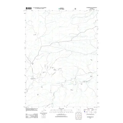
2012 Map of Esterbrook
USGS Topo · Published 2012About this map
Esterbrook sits as a central point of settlement in this high-altitude landscape, where the road network transitions from Esterbrook Rd into various forest service routes such as Forest Rd 633. The geography is defined by a series of prominent peaks and drainages, including the massive Elk Mountain and the distinct formation known as The Limestone. Local landmarks like Castle Rock and Sunset Hill provide orientation across a terrain carved by numerous seasonal and perennial waterways like Three Cripples Cr and N Horseshoe Cr. Evidence of ranching and recreational use is clear through the presence of the Macfarlane Ranch and the Esterbrook Campground, indicating a region where agriculture and forest management overlap. The distribution of named draws, such as Wildcat Draw and Horse Draw, reflects a landscape deeply mapped for local navigation and traditional land use.
Find a feature on this map
38 named features on this map. Tap any name to fly to it.
Don’t see what you’re looking for? This feature index may not catch every label — zoom into the map to look around manually.
Map Details
Editions of this 2012 Esterbrook Map
This is the sole edition of this map. No revisions or reprints were ever made.
Other maps of this area

1943 · Esterbrook
USGS Topo · 1:62,500

1945 · Esterbrook
USGS Topo · 1:62,500

1949 · Poison Lake
USGS Topo · 1:24,000

1949 · Cedar Hill
USGS Topo · 1:24,000

1949 · Spring Creek
USGS Topo · 1:24,000

1949 · Dilts Ranch
USGS Topo · 1:24,000

1950 · Spring Creek
USGS Topo · 1:24,000

1950 · Poison Lake
USGS Topo · 1:24,000
1950 · Dilts Ranch
USGS Topo · 1:24,000

1950 · Cottonwood Falls
USGS Topo · 1:24,000