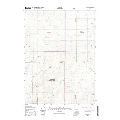
2015 Map of Esterbrook
USGS Topo · Published 2015About this map
The settlement of Esterbrook sits at the heart of this high-elevation landscape, where the borders of Converse, Albany, and Platte counties converge. This 2015 survey illustrates a terrain defined by significant peaks and drainage systems within the Medicine Bow National Forest. The map detail shows a complex network of forest roads, including Harris Park Rd and Esterbrook Rd, connecting isolated landmarks and water sources. To the north, the Fred Dilts Reservoir Number 4 and Elkhorn Cr drain the uplands, while the southern reaches are marked by distinct geological features like Castle Rock and the limestone formations near Horse Draw. This documentation provides a clear view of the ranching and timber geography of the region, anchored by family-named landmarks and the persistent paths through the mountainous backcountry.
Find a feature on this map
44 named features on this map. Tap any name to fly to it.
Don’t see what you’re looking for? This feature index may not catch every label — zoom into the map to look around manually.
Map Details
Editions of this 2015 Esterbrook Map
This is the sole edition of this map. No revisions or reprints were ever made.
Other maps of this area

1943 · Esterbrook
USGS Topo · 1:62,500

1945 · Esterbrook
USGS Topo · 1:62,500

1949 · Poison Lake
USGS Topo · 1:24,000

1949 · Cedar Hill
USGS Topo · 1:24,000

1949 · Spring Creek
USGS Topo · 1:24,000

1949 · Dilts Ranch
USGS Topo · 1:24,000

1950 · Spring Creek
USGS Topo · 1:24,000

1950 · Poison Lake
USGS Topo · 1:24,000
1950 · Dilts Ranch
USGS Topo · 1:24,000

1950 · Cottonwood Falls
USGS Topo · 1:24,000