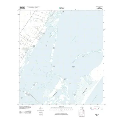
2010 Map of Estes
USGS Topo · Published 2010About this map
Arkansas Bay and Redfish Bay dominate this coastal landscape, where a complex network of islands and shoals separates the mainland from the Gulf of Mexico. In the early 21st century, residential developments like City-by-the-Sea and Palm Harbor show the transition of the shoreline toward recreation and maritime living, supported by the Palm Harbor Marina and Fin and Feather Marina. These modern settlements contrast with the older coastal footprint indicated by the Old Terminal and the San Antonio Cemetery.
Find a feature on this map
44 named features on this map. Tap any name to fly to it.
Don’t see what you’re looking for? This feature index may not catch every label — zoom into the map to look around manually.
Map Details
Editions of this 2010 Estes Map
This is the sole edition of this map. No revisions or reprints were ever made.
Other maps of this area

1925 · Aransas Pass
USGS Topo · 1:62,500

1950 · Corpus Christi
USGS Topo · 1:250,000

1951 · Allyns Bight
USGS Topo · 1:24,000

1952 · St. Charles Bay SW
USGS Topo · 1:24,000

1953 · Beeville
USGS Topo · 1:250,000

1954 · Rockport
USGS Topo · 1:62,500

1954 · Aransas Pass
USGS Topo · 1:24,000

1954 · Port Ingleside
USGS Topo · 1:24,000

1954 · Estes
USGS Topo · 1:24,000
1954 · Port Aransas
USGS Topo · 1:24,000