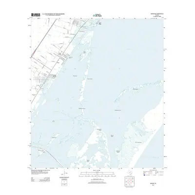
2013 Map of Estes
USGS Topo · Published 2013About this map
The intricate coastal architecture of the Texas Bend is detailed here, centered on the residential and maritime developments of Palm Harbor and the appropriately named City-By-The-Sea. The landscape is dominated by the complex interface of Aransas Bay and Corpus Christi Bay, separated by a chain of islands and shoals including Traylor Island, Shellbank Island, and the massive San Jose Island. Navigation is a primary focus, with the Lydia Ann Channel and various cuts like Big Cut and Little Cut providing passage through the Estes Flats. For local history researchers, the map identifies the small community of Estes, the San Antonio Cemetery, and various family-named roads such as Balderee Lane and Ruby Allen Street. The presence of the Old Terminal and multiple marinas, including the Fin and Feather Marina at Stedman Island, reflects the area's deep-rooted connection to the Gulf's commercial and recreational waters.
Find a feature on this map
82 named features on this map. Tap any name to fly to it.
Don’t see what you’re looking for? This feature index may not catch every label — zoom into the map to look around manually.
Map Details
Editions of this 2013 Estes Map
This is the sole edition of this map. No revisions or reprints were ever made.
Other maps of this area

1925 · Aransas Pass
USGS Topo · 1:62,500

1950 · Corpus Christi
USGS Topo · 1:250,000

1951 · Allyns Bight
USGS Topo · 1:24,000

1952 · St. Charles Bay SW
USGS Topo · 1:24,000

1953 · Beeville
USGS Topo · 1:250,000

1954 · Rockport
USGS Topo · 1:62,500

1954 · Aransas Pass
USGS Topo · 1:24,000

1954 · Port Ingleside
USGS Topo · 1:24,000

1954 · Estes
USGS Topo · 1:24,000
1954 · Port Aransas
USGS Topo · 1:24,000