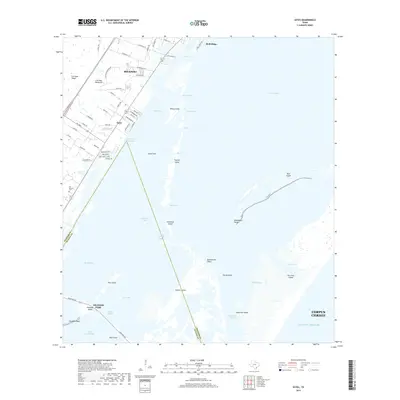
2019 Map of Estes
USGS Topo · Published 2019About this map
The complex shoreline of the Live Oak Peninsula and the barrier island systems of the Texas Gulf Coast define this coastal survey. The settlement of Estes and the southern edge of Rockport are situated along the Intracoastal Waterway, where residential developments like Port Royal and Port Saint Claire front the water. The map documents the intricate network of cuts, bayous, and flats that separate the mainland from major landforms such as San Jose Island and Harbor Island.
Find a feature on this map
75 named features on this map. Tap any name to fly to it.
Don’t see what you’re looking for? This feature index may not catch every label — zoom into the map to look around manually.
Map Details
Editions of this 2019 Estes Map
This is the sole edition of this map. No revisions or reprints were ever made.
Other maps of this area

1925 · Aransas Pass
USGS Topo · 1:62,500

1950 · Corpus Christi
USGS Topo · 1:250,000

1951 · Allyns Bight
USGS Topo · 1:24,000

1952 · St. Charles Bay SW
USGS Topo · 1:24,000

1953 · Beeville
USGS Topo · 1:250,000

1954 · Rockport
USGS Topo · 1:62,500

1954 · Aransas Pass
USGS Topo · 1:24,000

1954 · Port Ingleside
USGS Topo · 1:24,000

1954 · Estes
USGS Topo · 1:24,000
1954 · Port Aransas
USGS Topo · 1:24,000